

Granger Island

Granger Island Cabin, Farnsworth Metropark, 225 S. River Road, Waterville, OH 43566 (photo courtesy of Doug Kampfer)
www.MetroparksToledo.com
Metroparks Toledo was recently named the best Metropark system in the nation. The organization has an incredible focus on community, recently completing its plan to have a park located within five miles of every Lucas County resident. It offers genuinely unique nature experiences that highlight the geography, geology, flora, and fauna of each of its park areas. Operating in a relatively flat (read boring) stretch of land to the naked eye, the Metroparks bring awareness to the wonder, excitement, and history of our natural landscape into the homes of everyday residents.
Spanning more than 8,300 square miles, the Maumee River and its tributaries compose the largest watershed flowing into the Great Lakes*. Along its course are ancient relics, including geological formations carved from the ice age, countless histories and artifacts from numerous indigenous tribes who settled along the area, remnants of the French and Indian War and War of 1812, and, of course, lots of influence from the Industrial Revolution. Today, the river is a burgeoning destination for recreation, including hiking, kayaking, and camping.

The campsite and river access at Granger Island in front of the cabin.
One of the most fascinating places to experience the river comes from the Metroparks’ Granger Island. Set in the middle of a near mile-wide span of the river in Waterville, OH, the island is available for overnight rentals. Featuring a pretty fancy rustic cabin (no water or electricity, lots of bugs, but overall pretty nice digs; $80/night) and two outdoor tent platforms ($25/night). Only accessible by canoe or kayak, just crossing the river to get to the campsite is an adventure in and of itself. Once there, though, guests have a prime spot to experience the heart of the Maumee.

Part of the natural process of the river, seasonal ice dams wreak havoc along the river and its islands, uprooting trees and scoring the shorelines (photo courtesy of Doug Kampfer).
Granger Island has a number of strange amenities for the adventurous spirit. It’s incredibly rustic, full of wildlife, and can be a challenge to cross early in the season when the water is moving high and fast. Local lore and rumors state that portions of it were Native American burial grounds (indeed, ice damage in the winter has revealed remains throughout the Maumee’s islands over the years), which can be revelatory, spooky, or exciting, depending on your flavor**.

Mud swallows abandoned cars in one section of the island, noting its not so distant private ownership and 20th century industrial era past.
What’s more, Granger Island has the distinction of being privately owned for much of the 19th and 20th centuries. For some reason, one of its more recent owners chose it as a place to park cars. For what reason or purpose seems to remain unclear, but wanderers will be rewarded with the odd site of a handful of tail-finned Chrystlers rotting into mud near the island’s western tip. It’s a confusing sight, strangely beautiful and creepy in the same breath.
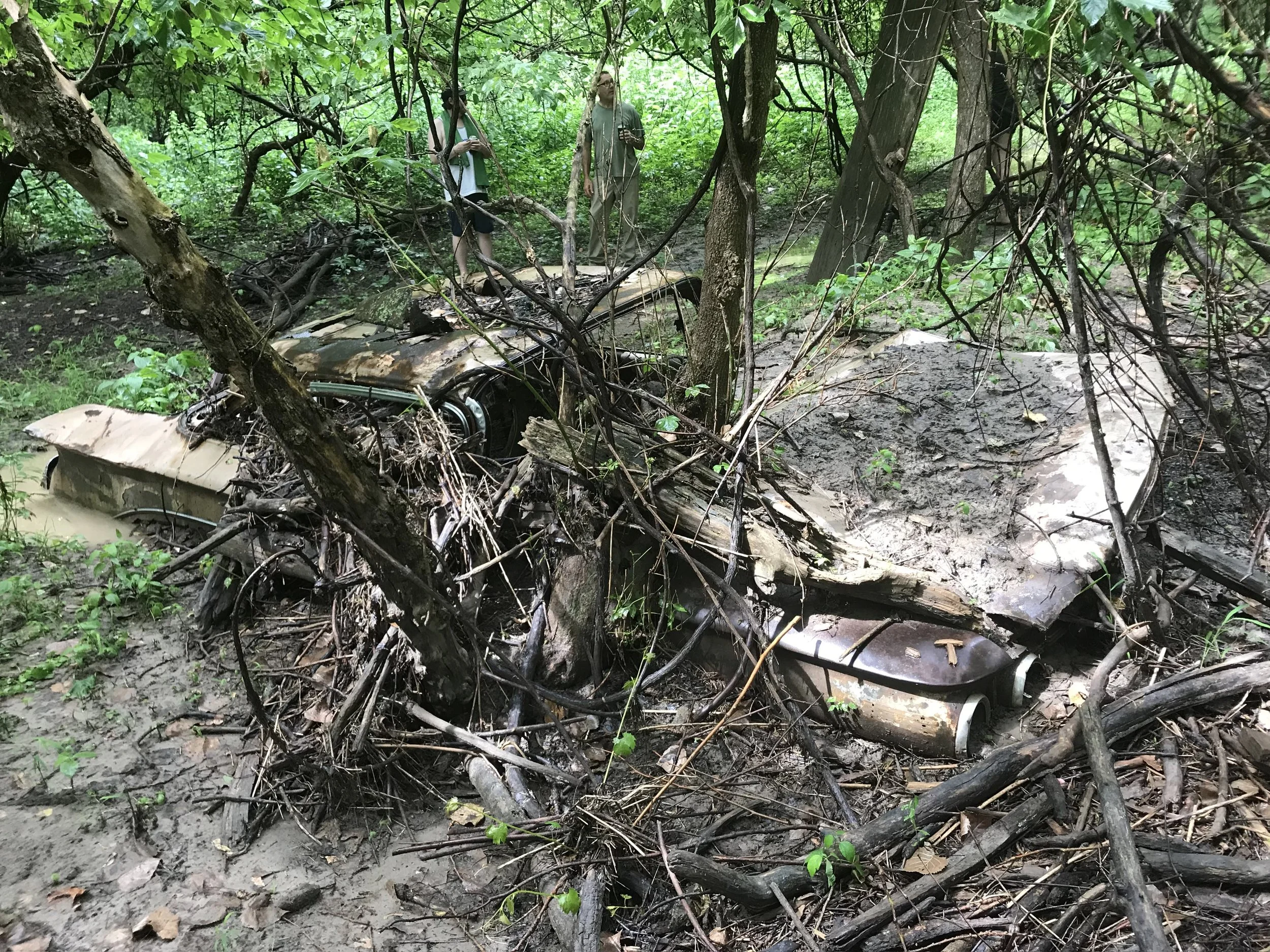
There is an odd beauty to nature adapting and reclaiming these once beautiful marvels of design and manufacturing.
By canoe or kayak, or, when the water is low later in the season and walkable, crossing to the south, there are incredible limestone and shale outcroppings revealed along the river’s edge. This bed rock, and the river itself, were exposed when the Laurentide Ice Sheet — a massive glacier that covered much of North America during the ice age — ground the area down to the bone.

Shale outcroppings near the edge of the river bank reveal the glacial history of the river’s formation (photo courtesy of Doug Kampfer).
From there, sitting in the water on this ancient-formed rock near as old as the earth itself, you can trace up the alluvial fans of sediment, a living history moving upward through the 20-foot bluffs and get a sense that this area, neither physically nor metaphorically, is flat at all.

Granger Island’s rustic beauty and remoteness are an escape from the bustle of everyday life and a reminder of the region’s geological wonder (photo courtesy of Doug Kampfer).
*It is worth noting that the Maumee River has been abused for much of its recent life, resulting in the Lake Erie Algae Bloom which caused the people of Toledo to be without drinking water for three days in 2014.
Learn about the Lake Erie Algae Bloom
**It is also worth noting that this area was considered by colonists essential to westward expansion and that the land was stolen, often brutally, from its native inhabitants, tribes, people, and histories who are very much still alive today.
We encourage readers to learn more about both of these subjects and to advocate, where possible, for their correction.